(Part 2 of an
multi-part travelogue)
Sunday, July 31, 2005
A sailing trip from the Polish town of Hel to Russia seems easy - only 35 nautical miles. Nevertheless, the preparation that needs to be done is considerable. You need a visa and a good schedule otherwise your trip to Russia will find a sudden end. We experienced something like this three years ago when we were expelled from the country without further ado.
At that time we were visiting Kaliningrad with a single-entry visa. During our stay at the
Kaliningrad Yacht Club we made friends with a Russian sailor and his family. Juri told us about the forthcoming port and fishery festival in Pionerski at the northern coast of the Kaliningrad oblast and invited us to follow him by boat. So we did - but a few hours later, when we informed the authorities in Baltijsk about our destination they refused to let us go. The background was obvious: Foreign boats leaving Baltijsk have to follow a determined course, unless it had been stipulated differently. This course runs perpendicularly from the coast towards international waterways. If you strictly follow the instructions and consider going to Baltijsk you make a second entry to Russia for which you will need a double entry visa. At that time we did not have it.
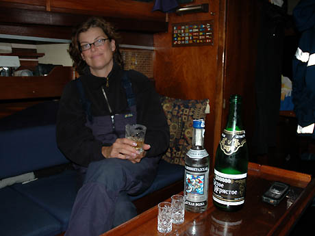
This time we did apply for a double entry visa and we got it. This time, we will sail from Baltijsk to Pionerski! The cost was about 150 Euro for one person including additional charges for an official invitation and a travel sickness cover - 300 Euro for two persons. If we would have gone to Spain we might have had nearly one week of all-inclusive holidays at the price, in Russia this sum is only the entrance fee!
In the early morning of July 31, 2005 at 07:40 am we gave a radio call to the Polish authorities clear outward. A few minutes later a German skipper asked us about the visa procedures for sailing boats, he also felt like sailing to Kaliningrad. We explained to him in a few words the "perils" of the entry formalities (see: "Applying for a Russian visa").
At 08:15 am we were on the Bay of Gdansk, Zatoka Gdanska. This was quite early considering our normal time schedule but Baltijsk, the former Pillau, was only half of the way we had to go.
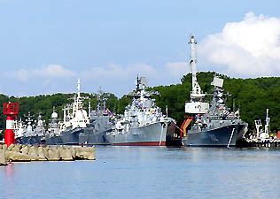
In Baltijsk huge naval forces are basedEven today, Baltijsk is still a military area. And until 1991 the whole Kaliningrad oblast was a prohibited area. You can clear inward in Baltijsk, however, you can not stay there with your boat. Our final destination, Kaliningrad, was about 25 nautical miles upcountry. You get there by the Kaliningrad sea channel which is quite comfortable to go but you are not entitled to stop anywhere because the waterway is highly frequented by big ships.
The channel crosses the
Vistula Lagoon where you could anchor in principle, however, the passages are highly shoaled and the lagoon is blotched with shelf. We could not buy any sea chart of the lagoon in Germany, and even in Russia we did not succeed - the only chart we could get was British which showed the channel. Reportedly the army is blocking the publication of appropriate charts. We later got to know that corresponding charts are supposedly available in Lithuania, but this did not help us at that moment. We also learned later on that it is possible to
sail the Vistula Lagoon - however, without a chart it is highly advised not to do it.
For us, one thing was certain: We could not stop anywhere and we had to go straightway to Kaliningrad by engine. Even the final destination, the Kaliningrad sailing club, was excluded because it is also situated in the Vistula lagoon and there are no buoys between the shoals. Furthermore, the night approach is risky. We therefore decided to go the free-port where - according to an information on the web - sailing boats can moor at a pier. So we did not only have 35 nautical miles to do, but 65 miles plus probably a one-hour border control.
Only a few days later we learned from a Russian sailor that there is an old harbour about 2 nautical miles south of Baltijsk near the Vistula lagoon which had been built by the Germans in former times. And we could have moored here for the night! (Entry: N 54° 37,1'/E 019° 53,3'). However, even this basin is strongly shoaled and you need a topical chart, in order to reach it. It is being considered to build a marina in that place.
At 5 p.m. Kaliningrad time we reached the harbour of Baltijsk. Just right in time and according to the
stipulations gave an English radio call to
Kaliningrad 47 - that's the Russian name for
Baltijsk Traffic - on channel 74 and asked for entrance which was permitted by return.
We spent about half an hour searching for the customs clearance and found it at the easterly end of the Baltijsk port. Without the radio guidance of
Kaliningrad Traffic - which was by the way given in perfect English - we would hardly have found basin number 3 which recently became the border control for Polish ferries and sailing boats (position N 54° 38,1' / E 019° 55,8'). Three years ago the customs clearance took place in the middle of the main basin of the Baltijsk port.
The Kaliningrad Sea Channel: A dredged fairway through the Vistula LagoonAfter a short hour of entry formalities they let us go and we went to Kaliningrad by engine through the wonderful sea channel which had been constructed in 1900. Due to good buoyage we found our way without problems; the channel meets the river Pregel (Russian: Pregolya) and we arrived safely before midnight in the free port. When leaving the Pregolya and going to the most easterly basin which is next to the city we see a sailing boat in its furthermost corner - however, a Russian boat without crew as we get to know later.
Whilst berthing - our ropes not yet properly moored - a female Russian officer in uniform came to our boat and announces in clear terms that we cannot berth here at all. On the other hand our attempt to do it was judged as such a grave offence against the rules that she forbade us strictly to leave again. We first would have to undergo an investigation. Claudia's knowledge of the Russian language was good enough to understand what she said but not good enough to appease the official.
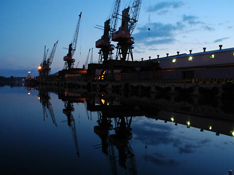
Free-port of Kaliningrad at nightFemale officers of higher ranks approached. They explained to us, that in a little while an even higher ranked colleague would come in order to decide our case. 30 long minutes later, he finally arrived. We were very astonished: He did not wear a uniform with any more stripes at all, but Jeans. We explained to him that we have learned on the web that this place was designed for mooring. He decided with a few words that we could stay until 07 am and vanished into the night. And we had the strong impression that this time the new Russia won the battle against the old one.
Monday, August 1, 2005
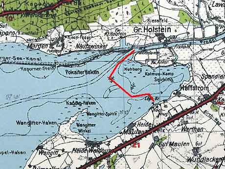
At 07:15 am we left the free-port. Our destination was the Kaliningrad sailing club. We had to go back nautical miles on the Pregolya river towards Baltijsk. At the junction buoy No. 37 where a waterway leaves into the lagoon I put the helm portside, course south-west. Within a few seconds the sonar showed alarming figures - and suddenly we got stuck in the soft mud. Our 45 year old diesel engine was tortured for minutes unless the boat got free and started to move backwards.
After our visit three years ago this was the third attempt to make the 3 nautical miles from the sea channel to the sailing club without grounding - and for the third time we failed, this time only after a few meters. I was angry and decided to note GSP waypoints in order to publish them.
Here they are:
- Leave the sea channel a few ship lengths west from buoy 37 (a red-green junction buoy) and take the passage to the lagoon. Try to stay at a maximum 10 meters from the westerly shore.
- Then run down the ship to an apparent red-green couple of buoys which is located 0,6 nautical miles away at 240°. The position of the buoys is N 54° 41,135' / E 020° 21,871'
- From there follow course 237° for about 0,7 nautical miles to a landfall buoy on N 54° 40,746' / E 020° 20,842. Watch out: Exactly on the baseline between the buoys and the landfall buoy, nearly half way between them, a wooden barricade sticks out of the water. Probably the rest of an old fishery net.
- From here it is only a few meters to reach the waypoint N 54° 40,655' / E 020° 20,943' which is southerly from a bunch of set nets.
- Reaching this waypoint, please go to N 54° 40,328' / E 020° 21,735' which is about course 115°.
- Now go to the very small approach buoy of the yacht club which is at N 54° 40,159' / E 020° 23,029'.
- At 140° you can see beacons at the entrance of the yacht club. Please stay on the line of bearing for about 0,25 nautical miles because the waters starboard are very shallow. The yacht club is at N 54° 39,962' / E 020° 23,305'.
This approach was trouble-free for our 1,41 m draught. When going back a few days later we succeeded for the first time without grounding. According to our sonar we even had a clearance of 30 cm at the shallowest point. However, this information is without any warranty.
The German map from 1938 shows: An extansive flat has to be passed in the South. -- [Historical map Pharus-Plan ( www.pharus-plan.de ) 'Samland 1938', licenced by pharus-plan-media ( www.pharus-plan-media.de )]At 09:40 we stern anchored in the yacht club. From our home port - Wolgast - we made exactly 300 nautical miles. We stayed four days in the old Prussian royal city.
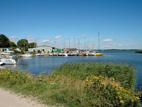
The KaliningradYacht ClubFrom the yacht club you can go by bus to the centre of Kaliningrad. The bus runs every few minutes.
Tuesday, August 2, 2005 until Thursday, August 4, 2005
Cortically Kaliningrad has a very Russian touch. However, its history is quite German.

Concrete tower-blocks dominate the townscape of the city of KaliningradSince the early middle-age the area around Königsberg was governed by the German order and later by the duchy of Prussia. East-Prussia, since 1773 a partial province of Prussia was separated by the Polish corridor after the First world war in 1919 under the Versailles treaty (see:
Memorial for General Haller von Hallenburg in Wladyslawowo). In 1939 East Prussia had 2.5 billion inhabitants. Only with the end of the Second world war the German era ended.
The Potsdam Conference in 1945 divided East Prussia into a Soviet and a Polish sector. The Russian part of its capital with its 15.000 square kilometres was quite smaller than the Polish part with 22.000 square kilometres. On July 4, 1946, one day after the death of Michail Kalinin, Königsberg was renamed into Kaliningrad. From 1926 until his death Kalinin was the chairman of the steering committee of the soviet government and therefore head of the Soviet Union.
Also in 1946 the whole Kaliningrad area became a prohibited area. Strangers were not allowed at all to go there, Soviet citizens only with a special permit. Only in 1991 the exclave became free and accessible. Today the county has 927.000 inhabitants out of which 394.000 live in the Pregolya metropolis.
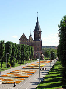
The Königsberg CathedralToday, the German past has nearly disappeared in the townscape. The Königsberg city castle, having been the residence of the Prussian kings for centuries, and having been the place where the Prussian kings were crowned in 1701 and 1861 was blown up in soviet times. The
Königsberg Cathedral (construction already started in 1330) is the only conserved important building of the old Königsberg. It hosts the tomb of
Immanuel Kant.
But even if the Kaliningrad area looks quite Russian today, the majority of Russian citizens in the exclave have a strong affection for the German history of the region. You always hear the saying: "It's 1.200 kilometres to go to Moscow, but only 600 to go to Berlin". In fact the Russian government attaches importance to the fact that the German name of the city remains extinct in official connections, but the inhabitants of the city prefer to call it rather "Kenig" then Kaliningrad, the local surf-club has been named "Kenig-Surf" and beer brands like "Königsberg Pils" or "Ostmark" sell well. And people who buy a car tend strongly to used German cars.
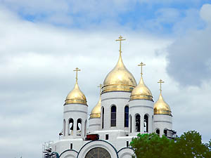
The orthodox Cathedral of Christ the Saviour (still under construction)But the people in the Kaliningrad region are by no means against their Russian roots. The language, the cyrillic letters, the cuisine, the Russian art or the classical roll of the family, all this means as lot to them and they are in many aspects much more traditional than Germans. But many long for a society where the individual can master his destiny on his own. In Russia this is much more difficult than in Germany and that's why the focus is very often on the West.
We spent four days in total in Kaliningrad and saw and experienced a lot. Two sights should absolutely be mentioned:
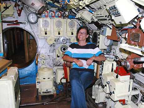
Claudia in the submarine B-413The
Museum of the World Ocean, being located in the city on the banks of the Pregolya, is without any doubt worth a visit. Though the exhibits inside the museum are rather moderate, the two museum ships outside on the Pregolya river are real attractions. The submarine B-413 was used by the Russian fleet until 1999 and is therefore one of the youngest museum submarines at the Baltic coasts. By the way: the assistants working on the 91.3 m long ship are polyglot.
Behind the submarine you will find the research vessel "Vitiaz" which was built in 1939 in Bremerhaven. Between 1946 and 1979 the vessel was travelling on all oceans under Russian flag. It has been affectionately restored and can be visited completely.
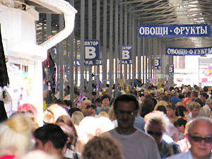
Crowd in the central market hallThe second recommendation is the central market of Kaliningrad which was always a big attraction for us. It is hard to imagine the multitude of goods in a Russian market if you have not experienced it. Maybe this is due to the fact that the industrial production of food has not yet flooded Russia the way it did in our countries or it is due to the Russian way of life and their traditional awareness - however, lots of things are much more tasty here, much more natural and it often reminds you of your childhood. Even simple things like cucumbers or young, white Tilsit cheese are delicacies and can be bought in dozens of qualities.
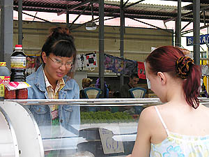
Attraction at the market: stand with korean specialtiesA great fascination at the market are several booths with Korean delicacies. Lots of starters and salads are sold here, many of them with seafood and the typical Korean seaweed. Asian cuisine has a great acceptance in Russia and this is not by chance: If you ignore that the Kaliningrad region is an exclave, North-Korea is after all a Russian abutter.
Friday, August 5, 2005
We did not receive the permission to go to Baltijsk, even though it was promised to us. Our plan was to go there by means of public transport. We therefore decided to leave Kaliningrad by boat for Pionerski.
At 11:40 we cast off and went by engine through the sea channel to Baltijsk. At 15:50 we arrived at the customs terminal and about 30 minutes later, we were en route.
After having made a pleasant experience with
Kalinigrad 47 (Baltijsk Traffic) upon arrival, we now dared to ask by radio on channel 74 for the permission to go to Pionerski near the coastline and got it without objection.
Due to weak winds we went by engine along the oblast's coast. The journey took us about 7 hours. At 23:10, shortly after nightfall, we reached the easily accessible harbour of Pionerski. A lady in uniform was already waiting for us at the footbridge. She was not interested at all in the fact that we prepared for this precious moment with a double-entry visa! She knew that we were not coming from the high seas and that we were therefore not re-entering Russia. Our nice and expensive visa was in vain!
A few days later we even met German sailors in the harbour who did the journey with a single-entry visa: First to Kaliningrad and then to Pionerski. Nevertheless the recommendation is: If you want to be on the safe side you should have a double entry visa.
Saturday, August 6, 2005 and Sunday, August 7, 2005
Before our trip we heard a lot about the coastal resorts Svetlogorsk (German: Rauschen) and Selenogradsk (German: Cranz) and we went to visit both sites. Both offer a beautiful and busy beach even they are totally different in their character.

Beach of SvetlogorskWithout any doubt, Svetlogorsk is much more popular amongst the Russian population. The beach and the esplanade are crowded. It's the resort for the new Russian middle class from all parts of the "empire", nevertheless, also shady new riches spend their holidays here. Just a few days before our arrival the Russian President Wladimir Putin met the German chancellor Schröder here. Svetlogorsk is a modern city which offers countless restaurants, pubs, shops and leisure activities to the tourists.
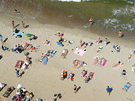
Some like it tight at the beach of SvetlogorskSelenogradsk on the other hand is a nice dozy village which committed itself a long time ago to tourism and remained rural.
By the way: If you take the train to go from Pionerski to Selenogradsk and Svetlogorsk (the central station is called
Svetlogorsk II) the time table is in Moscow time. Please deduct one hour to convert to Kaliningrad time.
The attractions of Pionerski (German: Neukuhren) are according to Claudia worth a closer inspection. It first looks rural like Selenogradsk. But it nearly offers anything what sailors need: A big supermarket with a vast choice of goods ("co-operative"), lots of pubs and even a do-it-yourself-store. And you have the choice between several internet cafes. One is located in the post office.
Monday, August 8, 2005
We had supper at one of the most romantic places of Pionerski the "Cafe Bika" on the cliffs over the sea. We had an excellent Russian speciality, Ucha, a fish soup made from cod, salmon and sturgeon. The sunset was maybe the most beautiful of my whole sailing life. I got up several times to look out of the window in order to watch the event. The read colour of the sky was amazing - and suddenly I remembered an old German saying: Evening's red - weather turns bad!
Tuesday, August 9, 2005
When getting up the barometer had lost 11 hPA since the afternoon of the previous day. We got to Svetlogorsk in order to do some shopping and to walk a little on the promenade. But heavy rain started in the early afternoon - and a strong wind which seems not threatening to us so far. Completely drenched, we took a taxi to the harbour of Pionerski. Upon arrival, a storm ran riot.
We were still on the footbridge and saw that our main sail is destroyed - disrupted, it fluttered in the wuthering storm. We did not fix it very much to the boom and the wind gusts got it free - finally a batten came under the rail and two sheets of the sail ripped over a distance of one meter from the leech.
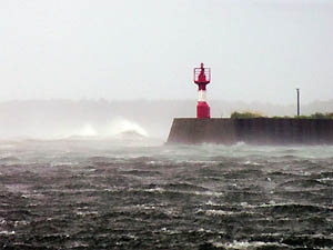
Storm in the harbour: view out of the harbour gateWe fixed the vestige to the boom and holed up into the boat.
But it was not enough. The barometer went down and down. In the evening we had have lost 18 hPA within the day. The harbour which was built in front of a steep coast and only protected by a mole had to cope with 10 Beaufort wind force from west. The boat heeled in its mooring with bare poles up to 20° under the wind gusts. I was terribly afraid that our cross tree would get caught under the forestay of a Russian 20 meter luxury yacht which moored next to us leeward, making exactly the same movements. But fortunately the oscillation of both boats in the storm is synchronous like ballet.
Outside the storm is howling - but fortunately in Russia one can buy best drinksWhat to do? Well - wait and drink Vodka. Finally, Claudia decided to watch a scary film on the DVD-player ("Shining!") whereas I think that the situation was already scaring enough without the movie!
Wednesday, August 10, 2005
At 4 am the storm finally diminished and the barometer had lost 24 hPA within 36 hours.
Rainbow over the harbour of PionerskiThe strong wind was over but it continued to pour rain for the next two and a half days. The day went by organizing the reparation of the sail. Valentin, the harbour master, helped us a lot. We found out that no sail maker is available in Pionerski and its surroundings, only in the Kaliningrad yacht club where we had been a few days ago. Valentin organized a private car for the next day - this day we could not go to Kaliningrad because the streets were impassable due to uprooted trees.
Thursday, August 11, 2005
In the morning Valentin and his friends waited for us at the fixed time with a Mercedes car at the pier. When going through the
Kaliningrad region we saw that the storm had uprooted dozens of big, old trees. The street was obstructed several times and the traffic was a chaos. Later we got to know that a sailor lost his life near Klaipeda. The storm had gone over all Baltic states. The athletic world championships in Helsinki were partially omitted.
Friday, August 12, 2005
At 1 pm
Volodja, the sail maker brought our main sail. The big mending was perfectly executed. All my fears that our sail would not have been able to make the 300 nautical miles on the open Baltic were in vain. We finally had an efficient boat again.
We then had to leave Pionerski as soon as possible because we were days behind our travel plan due to the weather conditions. But again - leaving was as complicated as arriving.
The wind meanwhile backed to 5 to 6 Beaufort south west. Going to Wladyslawowo at the Polish coast would mean tacking. Since our old steel yacht was not a racing boat, this target may have taken a long time. The Swedish island Öland was probably the better option. If the wind remains westerly it would be much easier to reach the Swedish west coast from there, rather than tacking in front of the Polish coast. But here in the harbour, under land coverage, it was difficult to determine the right wind. The courses on the high sea were uncertain from our actual point of stay.
And there was another challenge: Off the coast of the Kaliningrad region a huge military area is located which extends over nearly 15,000 square kilometers. It starts north of the fairway to Baltijsk and goes up to the Lithuanian sea border. The areas next to the coast are normally excluded with one exception: Cape Taran at the north-westerly corner of the Kaliningrad region. This means that you cannot go back to the Gdansk bay along the coast when military exercises take place.
We learned from our Navtex that from Friday 8 pm to Monday 6 am a cease fire would be held at Cape Taran. We would have to go during this time unless we decided to go 50 nautical miles north to the Lithuanian Klaipeda in order to pass the area northbound.
My plan: We cast off on Saturday morning and cross the section on the open sea. We then could decide if we go to Poland or Sweden. In the latter case we would have to go on for a night and another day - not very comfortable, twosome.
We informed Valentin, the harbour master, that we wanted to leave the next morning. A little later, at 2pm the corresponding customs official came to our boat. He informed us in broken English that a departure on Saturday would not be possible. The customs would only work on working days. And Friday was even a short day only until 03:30pm.
We heatedly argued and declared that we could not wait until Monday because Cape Taran would be under fire on that day. And we declared that we were not quite willing to leave at once, on Friday afternoon, because we would then have to spend two nights on sea, if the winds forced us to go to Sweden. We furthermore declared, that we had not yet got a reliable weather report. We normally analyze very carefully the charts of the
British weather data center Bracknelland we use to
download them from the web. We had the last analysis on Thursday morning in the internet cafe. And they were not really thorough, it was just a quick research to survey the storm. The menace of a Russian official, to send us two nights out on the Baltic without reliable weather data was not a comfortable idea.
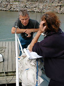
Talk at the fore deck: Harbourmaster Valentin gave us much assistance at the authoritiesValentin, who knew our distress pulls out all the stops. He gave phone calls and even visited the headquarter of the customs office in the harbour together with Claudia. In vain. The knocking-off time and the leisure weekend of the officer stood like a stone wall. With grinding teeth I decided that we leave immediately and not only on Monday.
A few minutes later the customs officer sat in our boat, smiling and prepared our departure documents. A few boxes and shelf have to be opened as a spot check. But the procedure was over by 3:30pm! We never went quicker through this program.
We then asked Valentin for the submarine exercises in a further sector of the military area in front of the coast. The exercises still continued on weekends. He said that we could pass the sector even during the exercises. However, we should ask for permission by radio when entering the area.
And then, we cast off on the Baltic.
By engine we went to the Cape Taran where we arrive shortly after 6pm. We then crossed the sector which was then under cease fire. Claudia then tried to inform the troops that we were going to enter the submarine area. However, nobody answered on any of the common channels. Finally she started an "all-ships"-call in order to ask Russian ships how to contact the military. But - the radio remained mute.
About midnight we sailed under second reef - however with the engine running - in order to leave the area as soon as possible westwards. Finally a huge ship with the silhouette of a battle ship appeared about half a nautical mile from us. I slowly bore away in order to dodge. But the warship also changed it's course - also northward and again we risked collision. I swore and put the helm over. Again the ship changed it's course and again it looked as if it was going to drive against us. I tacked and went further portside. I swore louder and louder. Meanwhile these manoeuvres already took us several minutes.
And in the same sudden way it started the strange spectacle was over: The battle ship tacked over portside and left our range of vision full ahead. A little later I guessed what this had been. We probably got very close to a submarine. The battle ship therefore pushed us away. When the submarine left, the "watchdog" could also retreat.
At about midnight we had done 30 nautical miles.
Saturday, August 13, 2005
The night was warm, the wind was at 5 Beaufort and came a few degrees more than south west.
Wladyslawowo was bloody far away with a wind like this. Whilst Claudia was sleeping I calculated both options. At a course of 290 to 300° - which was our actual course - we would deviate a lot from the Polish coast. This meant that the way to Wladyslawowo would be as long as the way to Grönhögen at the most southerly point of Öland. I checked all ways with the GPS.
When I went to sleep a little later, Claudia discovered the waypoint Grönhögen on the GPS. We had already spent 12 hours at sea and there were still 95 nautical miles to the next way point on the display. This resulted in a violent debate upon my waking up. I checked all data again with Claudia and explained to her that Wladyslawowo is not nearer that the actual way point. I recalled that it would be more easy for us to go south west from the Swedish coast than to tack along the Polish coast. She finally gave up and we went to Sweden. The wind diminished a little, we took out the reef and sailed close to the wind.
But only two hours later the wind was back to 6 Beaufort. We were on the furthest point of the open Baltic, water around wherever we look for at least 80 nautical miles - looking south west the distance to the shore was surely about 200 nautical miles. The forthcoming sea state was quite sporty. At lunch time waves were about 2 meter high. And in the afternoon the wind reached 7 Beaufort with 3 meter waves. We sailed under the second reef.
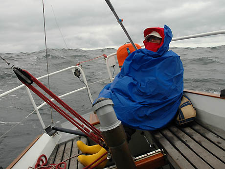
Claudia fighting against 2-meter-waves, later they will have 3 metersAt such a sea state it was impossible to go close-hauled, especially with our old steel yacht. The only way was to ride on the waves and to bear away a little. Otherwise the boat would dunk too often and vast quantities of water would break on the deck. This was not only dangerous for the material. At this stage we found out that we would not reach Grönhögen but only point much more in the North of the Öland coast. I checked the sea charts and harbour compendiums for a place to go. Most of the few harbours at the east coast of the longest Swedish island were to shallow, except one: Bläsinge.
At midnight the sea got calmer. We approached the Swedish coast. And the waves meeting us from portside were much more moderate than those of the past afternoon.
Sunday, August 14, 2005
At 06:45 am we arrived at Bläsinge berth at Öland after 40 hours and 164 nautical miles.
Next: Part 3 - A Short Detour to Sweden